Thursday, March 28, 2013

LaGuardia Airport


     LaGuardia Airport is an airport in the northern part of the New York City borough of Queens. The airport is on the waterfront of Flushing Bay and Bowery Bay, and borders the neighborhoods of Astoria, Jackson Heights and East Elmhurst.
     The New York City metropolitan area's JFK International, LaGuardia, and Newark Liberty International airports combine to create the largest airport system in the United States.The airport is a domestic hub for Delta Air Lines and a focus city for American Airlines and regional affiliate American Eagle.
     The airport was originally named Glenn H. Curtiss Airport after aviation pioneer Glenn Hammond Curtiss then renamed North Beach Airport,The official name after New York City's takeover and reconstruction was New York Municipal Airport-LaGuardia Field, then in 1953 named solely "LaGuardia Airport" for Fiorello La Guardia, the mayor of New York when the airport was built.


Thursday, March 14, 2013

Manhattan Bridge


     The Manhattan Bridge is a suspension bridge that crosses the East River in New York City,connecting Lower Manhattan with Brooklyn.It was the last of the three suspension bridges built across the lower East River, following the Brooklyn and the Williamsburg bridges. The bridge was opened to traffic on December 31, 1909 and was designed by Leon Moisseiff,who later designed the infamous original Tacoma Narrows Bridge that opened and collapsed in 1940. It has four vehicle lanes on the upper level. The lower level has three lanes, four subway tracks, a walkway and a bikeway. The upper level, originally used for streetcars, has two lanes in each direction, and the lower level is one-way and has threelanes in peak direction. It once 
carried New York State Route 27 and later was planned tocarry Interstate 478. No tolls are charged for motor vehicles to use the Manhattan Bridge.


Construction started          October 1, 1901
Opened to traffic               December 31, 1909
Length of main span          1,470 ft.
Total length of bridge
including approaches         6,855 ft.
Location                           Connects Flatbush Avenue in Downtown
                                        Brooklyn with Canal Street in Chinatown


Tuesday, March 12, 2013

Flatiron Building


     The Flatiron Building is located at 175 Fifth Avenue in the borough of Manhattan, New York City and is considered to be a groundbreaking skyscraper. Upon completion in 1902, it was one of the tallest buildings in the city.The building sits on a triangular island-block formed by Fifth Avenue, Broadway and East 22nd Street, with 23rd Street grazing the triangle's northern (uptown) peak. 
     As with numerous other wedge-shaped buildings, the name "Flatiron" derives from its resemblance to a cast-iron clothes iron.The building anchors the south (downtown) end of Madison Square and the north (uptown) end of the Ladies' Mile Historic District. The neighborhood around it is called the Flatiron District after its signature building, which has become an icon of New York City.
     As an icon of New York City, the Flatiron Building is a popular spot for tourist photographs, but it is also a functioning office building which is currently the headquarters of publishing companies


Friday, March 1, 2013

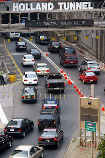
Holland Tunnel


     The Clifford Milburn Holland Tunnel (more commonly known as the Holland Tunnel) is a highway tunnel under the Hudson River connecting the island of Manhattan in New York City with Jersey City, New Jersey at Interstate 78 on the mainland of the United States.
     Begun in 1920 and completed in 1927, the tunnel is named after Clifford Milburn Holland (1883–1924), Chief Engineer on the project, who died before it was completed. Tunnel designer Ole Singstad finished Holland's work. The tunnel is one of the earliest examples of a mechanically ventilated design.
    The tunnel consists of a pair of tubes, each providing two lanes in a 20-foot (6 m) roadway width and 12.5 feet (3.8 m) of headroom. The north tube is 8,558 feet (2,608 m) from end to end, while the south tube is slightly shorter at 8,371 feet (2,551 m). Both tubes are situated in the bedrock beneath the river, with the lowest point of the roadway approximately 93 feet (28 m) below mean high water.